Big Bear Mountain Biking Trail Guide Maps GPS - Hiking Trails too!
  • Home
    • Big Bear Mountain Bike Blog
    • Big Bear Bike Forums
    • Snowshoe Club>
      • Sugarloaf Mountain
  • Mountain Bike Trails
    • 2N10 WEST TRAILS>
      • Cabin 89 Singletrack Trail>
        • Upper Cabin 89 Trail
      • Plantation Trail
      • Stonehenge Trail
      • Boulder Creek Trail
    • 2N10 EAST SNOW SUMMIT AREA>
      • Skyline Trail *NEW Singletrack for 2013*
      • Downhill Trails @ Snow Summit
      • Pine Knot Trail>
        • Pine Knot Trail -1e01
      • Towne Trail
      • Snow Forest Trail 2N08 Singletrack
      • Plumber's Trail (2012)
    • NORTH SIDE / FAWNSKIN>
      • Grout Bay - Hanna Flats Loop w/Gray's Peak Trail - Fawnskin, CA (Big Bear Lake, Ca)
      • Gray's Peak Trail - Fawnskin, CA (Big Bear Lake, Ca)
      • Butler Peak Fire Lookout Fireroad Climb (Big Bear Lake, Ca)
      • Cougar Crest to Bertha Peak Trail
      • Woodland Nature Trail
      • Don't Shoot Me Trail
    • Epic XC Rides>
      • Big Bear Epic XC Loop #1
      • Big Bear Epic XC Loop #34
      • Big Bear XC Ride #5
      • Big Bear XC Ride #9
    • NEARBY>
      • Exploration Trail
      • Santa Ana River Trail Guide>
        • SART "Segment 0" Wildhorse Trail
        • SART "Segment 1" Southfork to Angeles Oaks
        • SART "Segment 2" Angeles Oaks to Morton Peak
        • SART "Segment 3" Morton Peak Singletrack to Redlands
        • Old Highway 38 to SART Loop (Loch Leven Santa Ana River Trail)
    • Trails coming soon... >
      • Polique to Delamar Connector Singletrack
      • Fern Trail
      • Snow Summit Chairlift MTB Loops
  • Snow Summit Downhill Runs
  • Big Bear Information
    • Hiking Trails>
      • Alpine Pedal & Walking Path
      • Best Hike from Big Bear Lake Village Area
      • Castle Rock Trail (**MUST DO** Most Scenic Destination)
      • Cougar Crest Trail
      • Pine Knot Trailhead Loops
      • Woodland Nature Trail
      • Siberia Creek Trail "Gunsight"
      • Gold Mountain Short Hike (Winter)
      • The PCT - Pacific Crest Trail
    • Big Bear Bicycle MTB Shops / Rentals
    • Big Bear Weather
    • Big Bear Paddle Guide
    • Other Things To Do in Big Bear Lake
    • Big Bear Beer / Pubs / Nightlife
    • Big Bear Lodge for Groups!
    • MTB Friendly Hostel
    • Buy a Big Bear Trail Map!
    • 4x4 Roads>
      • Gold Fever Self Guided History Tour

Butler Peak Fire Lookout from Grout Bay with some bonus singletrack. 
Start at 6677ft and goes to 8390ft at peak

The fire road to Butter Peak Fire Lookout has been closed since a 2007 forest fire. It's a great ride for mountain biking or hiking because you don't have to worry about cars are jeeps. the view on a clear day is amazing. I could see Catalina Island clearly with the naked eye. Views of Lake Arrowhead , Big Bear Lake, Snow Valley ski resort and the high desert all from one location.

Ride from where ever you are to Fawnskin. The Grout Bay / Gray's Peak Trailhead is 1 mile West of Fawnskin on the Highway 38. Ride up the trail, take the fireroad to the right when you enter a big clearing. Go past Gray's peak trailhead 100 ft and find trail to Hanna Flats. Take this trail. It will cross 1 or two fireroads and then it will hit a fireroad with gravel on it. This is 2n13, follow it all the way to Butler Peak. Go back how you came. Awesome!
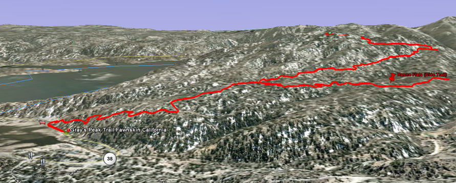
Big Bear Lake to Butler Peak Fire Lookout Tower Mountain Bike

3D View   

This is a 3d view in Google Earth of the hike from the Gray's Peak parking lot. The trail that goes off to the right goes to Hanna Flats and the Trail
Picture
Thanks to Big Bear Valley Trails Foundation for creating new trails and promoting big bear trails.
© 2001-Today, All Rights Reserved. BigBearHostel.com

Site Design by AdvertiseBigBear.com (Contact us to Advertise Here!)Join BigBear247.com for free web advertising!

WARNING:
Mountain Biking, Hiking and even watching TV on your sofa can be deadly!
Always take, food, water, warm clothes, compass, GPS, Map, Cell Phone, First Aid, doctor, friend, extra survival equipment into the National Forest or wilderness. 
This site is for informational reference purposes only. Trails may be unmarked, marked, or not even exist anymore. Use at your own risk. 


Photos used under Creative Commons from ArkansasOutside.com, Rick's Images