Don't Shoot Me - Big Bear City, CA ( GPS MAP Pictures )
Elevation: ~200ft
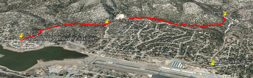
Start: Shepard in the Pines Church 6666ft,
End: Van Dusen Rd. 6850ft
Distance: 2 miles each way!
I mountain bike GPS'd this trail in Feb. and it was great riding with no snow. Grout bay trail still had snow. So this is the best bet before or after winter. Its a technical singletrack, ride-able both ways. Also great to jump on if you are coming down Van Dusen Canyon Rd. Its about 200 feet of descent from Van Dusen to the church. If you are heading back toward Big Bear Lake you can get in an extra 1.5 mile lap by swinging through Woodland Trail. I guess people call this "Don't Shoot Me" since it goes by the Gun Club parking lot. When they are shooting it is a little unnerving. Don't worry, they shoot into a hillside away from the trail.
You can get to the top by:
Share the Trail! - You may see horses or hikers here.
Guide by Grayson - www.BigBearHostel.com
You can get to the top by:
- Go North West from Singing in the Pines Church parking lot (look for tracks)
Share the Trail! - You may see horses or hikers here.
Guide by Grayson - www.BigBearHostel.com
Don't Shoot Me as seen in Google Earth
Download bigger version of this 3d image.
| shootme.jpg |
Download .KMZ file to Google Earth or your GPS device below!
| shootme.kmz |
Video
coming soon..