Big Bear Mountain Biking Trail Guide Maps GPS - Hiking Trails too!
  • Home
    • Big Bear Mountain Bike Blog
    • Big Bear Bike Forums
    • Snowshoe Club>
      • Sugarloaf Mountain
  • Mountain Bike Trails
    • 2N10 WEST TRAILS>
      • Cabin 89 Singletrack Trail>
        • Upper Cabin 89 Trail
      • Plantation Trail
      • Stonehenge Trail
      • Boulder Creek Trail
    • 2N10 EAST SNOW SUMMIT AREA>
      • Skyline Trail *NEW Singletrack for 2013*
      • Downhill Trails @ Snow Summit
      • Pine Knot Trail>
        • Pine Knot Trail -1e01
      • Towne Trail
      • Snow Forest Trail 2N08 Singletrack
      • Plumber's Trail (2012)
    • NORTH SIDE / FAWNSKIN>
      • Grout Bay - Hanna Flats Loop w/Gray's Peak Trail - Fawnskin, CA (Big Bear Lake, Ca)
      • Gray's Peak Trail - Fawnskin, CA (Big Bear Lake, Ca)
      • Butler Peak Fire Lookout Fireroad Climb (Big Bear Lake, Ca)
      • Cougar Crest to Bertha Peak Trail
      • Woodland Nature Trail
      • Don't Shoot Me Trail
    • Epic XC Rides>
      • Big Bear Epic XC Loop #1
      • Big Bear Epic XC Loop #34
      • Big Bear XC Ride #5
      • Big Bear XC Ride #9
    • NEARBY>
      • Exploration Trail
      • Santa Ana River Trail Guide>
        • SART "Segment 0" Wildhorse Trail
        • SART "Segment 1" Southfork to Angeles Oaks
        • SART "Segment 2" Angeles Oaks to Morton Peak
        • SART "Segment 3" Morton Peak Singletrack to Redlands
        • Old Highway 38 to SART Loop (Loch Leven Santa Ana River Trail)
    • Trails coming soon... >
      • Polique to Delamar Connector Singletrack
      • Fern Trail
      • Snow Summit Chairlift MTB Loops
  • Snow Summit Downhill Runs
  • Big Bear Information
    • Hiking Trails>
      • Alpine Pedal & Walking Path
      • Best Hike from Big Bear Lake Village Area
      • Castle Rock Trail (**MUST DO** Most Scenic Destination)
      • Cougar Crest Trail
      • Pine Knot Trailhead Loops
      • Woodland Nature Trail
      • Siberia Creek Trail "Gunsight"
      • Gold Mountain Short Hike (Winter)
      • The PCT - Pacific Crest Trail
    • Big Bear Bicycle MTB Shops / Rentals
    • Big Bear Weather
    • Big Bear Paddle Guide
    • Other Things To Do in Big Bear Lake
    • Big Bear Beer / Pubs / Nightlife
    • Big Bear Lodge for Groups!
    • MTB Friendly Hostel
    • Buy a Big Bear Trail Map!
    • 4x4 Roads>
      • Gold Fever Self Guided History Tour

Pine Knot Trail - Big Bear Lake, CA ( GPS MAP Pictures )
Elevation: Mill Creek Picnic 6865ft, Grandview Point 7688ft
Distance: Just over 3 miles!

Pine Knot Trail is the longest up/down singletrack on the South side of the lake. In 2013 the trailhead was moved to the back of the Mill Creek Rd. / Aspen Glen Picnic Area. 2/3mi of the old trail was closed and a new 1 mile of beautiful singletrack through black oak forest was created. This new singletrack is hike-able and ride-able in both directions. The Pine Knot Trail is now about 3.5 miles long. If you take it all the way to the end you will be at Grandview Point. Grandview point is a spectacular view where you can see the entire San Gorgonio mountain range. San Gorgonio is the highest point in S. California at 11,500ft.  
The Pine Knot Trail can be used to access Cabin 89 trail as a loop (see below) or it joins with the Skyline Trail about 3 miles up from Mill Creek Rd.
While the trail can be challenging for those not used to the thin air at altitude, this is the easiest trail on the South side of the lake. 
You can now hike or mountain bike a short loop or longer loop in addition to the out and back pine knot trail. 

Share the Trail! - Heavily traveled by hikers and bikers

Guide by Grayson - www.BigBearHostel.com

Pine Knot Trail Out and Back


This is the route you would follow if doing and out and back on Pine Knot Trail from Mill Creek parking lot.
Not sure why elevation aren't working here but distance is accurate.

Pine Knot / Cabin 89 Short Loop


Pine Knot Cabin 89 Long Loop

pine_knot_long_loop_to_cabin_89.gpx
File Size: 181 kb
File Type: gpx
Download File

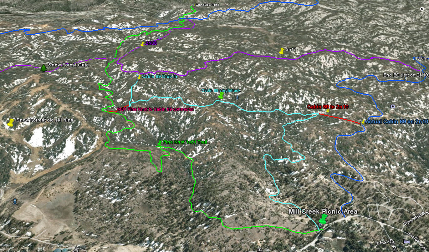
Pine Knot Trail as seen in Google Earth

Castle Rock Trail

Download bigger version of this 3d image.

pineknottrailge.jpg
File Size: 387 kb
File Type: jpg
Download File

Download .KMZ file to Google Earth or your GPS device below!

1e01_-_pine_knot_trail.kmz
File Size: 8 kb
File Type: kmz
Download File

Pine Knot Trail 1e01 Video

Grandview point to Aspen Glen Picnic Area viedo bike descent. Fun flowing singletrack all the way! 

Big Bear Trails Foundation Pine Knot Trail Tour Video

Pine Knot Trail Guide- Big Bear CA from hightrails on Vimeo.

© 2001-Today, All Rights Reserved. BigBearHostel.com

Site Design by AdvertiseBigBear.com (Contact us to Advertise Here!)Join BigBear247.com for free web advertising!

WARNING:
Mountain Biking, Hiking and even watching TV on your sofa can be deadly!
Always take, food, water, warm clothes, compass, GPS, Map, Cell Phone, First Aid, doctor, friend, extra survival equipment into the National Forest or wilderness. 
This site is for informational reference purposes only. Trails may be unmarked, marked, or not even exist anymore. Use at your own risk. 


Photos used under Creative Commons from ArkansasOutside.com, Rick's Images