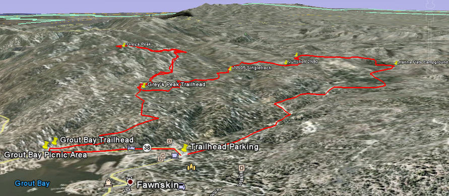
Fawnskin to Hanna Flats to Grout Bay Loop with Gray's Peak Trail option
Elevation: Start 6760ft (lake level) - Gray's Peak 7930
Distance: 11 miles (as ridden below)
This is a great trail for hiking or biking. It is the longest Singletrack in Big Bear. After the first 1/2 mile you will feel like you are in the middle of nowhere and there is nothing but the peace and quiet of the animals and the blissful XC singletrack.
Notes: The loop below is done by parking at the Fawkskin triangle. Then mountain biking 2.2 files up a paved/dirt road to Hanna Flats Campground. Near the Southwest corner of the campsite loop road you will find the Singletrack between two campsites across from the concrete bathroom building.
Mile 2.2 to 4.9 is singletrack that crosses many fireroads. The trail is fairly well marked. Follow other's tracks in dirt.
At mile 4.9 you hit a fireroad. Go left 200ft and you will see the Gray's Peak Singletrack optional out and back. (2 miles each way)
When you see a yellow post and the trail ends, park your bike and climb on the rocks that look over the lake, eat snacks!
To get back to Grout Bay or Fawnskin from Gray's Peak trailhead, go East on fireroad, stay left at Y, go left (North) at next junction (singletrack). This takes you to Grout Bay Trailhead. Ride left on Highway to get back to Fawnskin.
Fawnskin to Hanna Flats to Grout Bay w/Gray's Peak option 3d Google Earth View
| grout_bay__hana_flats__greys_peak_loop.kmz |