The Ultimate Mountain Bike Guide to Santa Ana River Trail Singletrack!
Maps GPS Pictures Video
The Santa Ana River Trail (SART) has three main segments of luscious Mountain Bike Singletrack.
While it is downhill overall, the grade is very mild and does go up in many places. This is XC riding.
There is also Sugarloaf Mountain and the Wildhorse Trail that can be ridden above Southfork.
You can ride any part separately or link them all together for one of the most amazing descents in the world!
110 miles from 9950ft Sugarloaf Mountain to the Pacific Ocean at Huntington Beach.
Segment 0a: Hatchery Road/Highway 38 (near Big Bear City) to Wildhorse Meadow (5mi)
Segment 0b: Wildhorse Meadow to Sugarloaf Mountain Out and Back
Segment 0c: Wildhorse Singletrack descent from Wildhorse Meadow to Highway 38
Segment 0d: Highway 38 Road Ride down to Southfork Parking Lot (top of SART)
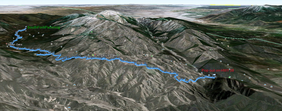
Segment 1: SART Southfork to Angeles Oaks
Segment 2: SART Angeles Oaks Singletrack to Morton Peak Fireroad
Segment 3a: Morton Peak Fireroad to Morton Peak
Segment 3b: Morton Peak SART Singletrack to Redlands (4.5mi singletrack, 2 mile fireroad & paved)
Segment 3b(alt) Morton Peak Singletrack to Redlands (Steeper singletrack than SART, one ridgeline to the north)
Loch Leven - Angeles Oaks - Old Highway 38 - SART Loop - 19 mi
1) Shuttle from top to bottom - Drop bike and riders at the top. Drive 2 cars down Glass Road and Seven Oaks Road and leave 1 car at the bridge where Seven Oaks road meets Mill Creek Road. Drive back up and start riding down to your car.
2) Park at Glass Road. Ride up or down as far as you want.
3) Park at top start point and ride down to Mill Creek Road, down to bridge, then all the way up the canyon roads to your car.
4) Ride down Wildhorse Trail which comes out on 38 above South Fork and make an EPIC Shuttle!
5) Start from the top of Poop Out Hill near Jenks Lake and tie in more singletrack!
6) Keep going from Angeles Oaks down the Lower SART!
While it is downhill overall, the grade is very mild and does go up in many places. This is XC riding.
There is also Sugarloaf Mountain and the Wildhorse Trail that can be ridden above Southfork.
You can ride any part separately or link them all together for one of the most amazing descents in the world!
110 miles from 9950ft Sugarloaf Mountain to the Pacific Ocean at Huntington Beach.
Segment 0a: Hatchery Road/Highway 38 (near Big Bear City) to Wildhorse Meadow (5mi)
Segment 0b: Wildhorse Meadow to Sugarloaf Mountain Out and Back
Segment 0c: Wildhorse Singletrack descent from Wildhorse Meadow to Highway 38
Segment 0d: Highway 38 Road Ride down to Southfork Parking Lot (top of SART)
Segment 1: SART Southfork to Angeles Oaks
Segment 2: SART Angeles Oaks Singletrack to Morton Peak Fireroad
Segment 3a: Morton Peak Fireroad to Morton Peak
Segment 3b: Morton Peak SART Singletrack to Redlands (4.5mi singletrack, 2 mile fireroad & paved)
Segment 3b(alt) Morton Peak Singletrack to Redlands (Steeper singletrack than SART, one ridgeline to the north)
Loch Leven - Angeles Oaks - Old Highway 38 - SART Loop - 19 mi
1) Shuttle from top to bottom - Drop bike and riders at the top. Drive 2 cars down Glass Road and Seven Oaks Road and leave 1 car at the bridge where Seven Oaks road meets Mill Creek Road. Drive back up and start riding down to your car.
2) Park at Glass Road. Ride up or down as far as you want.
3) Park at top start point and ride down to Mill Creek Road, down to bridge, then all the way up the canyon roads to your car.
4) Ride down Wildhorse Trail which comes out on 38 above South Fork and make an EPIC Shuttle!
5) Start from the top of Poop Out Hill near Jenks Lake and tie in more singletrack!
6) Keep going from Angeles Oaks down the Lower SART!
Santa Ana River Trail (ride as a loop from Angeles Oaks)
Santa Ana River Trail
(Southfork down past Angeles Oaks almost to Morton Peak)
Below is a view from Google Earth of Southfork to Angeles Oaks to HWY 38
Santa Ana River Trail on Strava
Here is a Southfork to Mentone ride on Strava on the Santa Ana River Trail for anyone who wants to use that interface / app.