Big Bear Mountain Biking Trail Guide Maps GPS - Hiking Trails too!
  • Home
    • Big Bear Mountain Bike Blog
    • Big Bear Bike Forums
    • Snowshoe Club>
      • Sugarloaf Mountain
  • Mountain Bike Trails
    • 2N10 WEST TRAILS>
      • Cabin 89 Singletrack Trail>
        • Upper Cabin 89 Trail
      • Plantation Trail
      • Stonehenge Trail
      • Boulder Creek Trail
    • 2N10 EAST SNOW SUMMIT AREA>
      • Skyline Trail *NEW Singletrack for 2013*
      • Downhill Trails @ Snow Summit
      • Pine Knot Trail>
        • Pine Knot Trail -1e01
      • Towne Trail
      • Snow Forest Trail 2N08 Singletrack
      • Plumber's Trail (2012)
    • NORTH SIDE / FAWNSKIN>
      • Grout Bay - Hanna Flats Loop w/Gray's Peak Trail - Fawnskin, CA (Big Bear Lake, Ca)
      • Gray's Peak Trail - Fawnskin, CA (Big Bear Lake, Ca)
      • Butler Peak Fire Lookout Fireroad Climb (Big Bear Lake, Ca)
      • Cougar Crest to Bertha Peak Trail
      • Woodland Nature Trail
      • Don't Shoot Me Trail
    • Epic XC Rides>
      • Big Bear Epic XC Loop #1
      • Big Bear Epic XC Loop #34
      • Big Bear XC Ride #5
      • Big Bear XC Ride #9
    • NEARBY>
      • Exploration Trail
      • Santa Ana River Trail Guide>
        • SART "Segment 0" Wildhorse Trail
        • SART "Segment 1" Southfork to Angeles Oaks
        • SART "Segment 2" Angeles Oaks to Morton Peak
        • SART "Segment 3" Morton Peak Singletrack to Redlands
        • Old Highway 38 to SART Loop (Loch Leven Santa Ana River Trail)
    • Trails coming soon... >
      • Polique to Delamar Connector Singletrack
      • Fern Trail
      • Snow Summit Chairlift MTB Loops
  • Snow Summit Downhill Runs
  • Big Bear Information
    • Hiking Trails>
      • Alpine Pedal & Walking Path
      • Best Hike from Big Bear Lake Village Area
      • Castle Rock Trail (**MUST DO** Most Scenic Destination)
      • Cougar Crest Trail
      • Pine Knot Trailhead Loops
      • Woodland Nature Trail
      • Siberia Creek Trail "Gunsight"
      • Gold Mountain Short Hike (Winter)
      • The PCT - Pacific Crest Trail
    • Big Bear Bicycle MTB Shops / Rentals
    • Big Bear Weather
    • Big Bear Paddle Guide
    • Other Things To Do in Big Bear Lake
    • Big Bear Beer / Pubs / Nightlife
    • Big Bear Lodge for Groups!
    • MTB Friendly Hostel
    • Buy a Big Bear Trail Map!
    • 4x4 Roads>
      • Gold Fever Self Guided History Tour

Pine Knot Trail - Big Bear Lake, CA ( GPS MAP Pictures )
Elevation: Mill Creek Picnic 6865ft, Grandview Point 7688ft
Distance: Just over 3 miles!

Pine Knot Trail is the longest singletrack on the South side of the lake.
Its a great MTB downhill but can also be ridden or hiked both ways.

You can get to the top by:
  1. Taking Snow Summit chairlift > 2n10 West > Grandview Point
  2. Ride up 2n08 from Knickerbocker
  3. Ride up Mill Creek Road > 2n10 > 2n17 > 2n08
  4. Ride up the trail itself

Share the Trail! - Heavily traveled by hikers and bikers

Guide by Grayson - www.BigBearHostel.com

Not sure why elevation aren't working here but distance is accurate.

Pine Knot Trail as seen in Google Earth

Castle Rock Trail

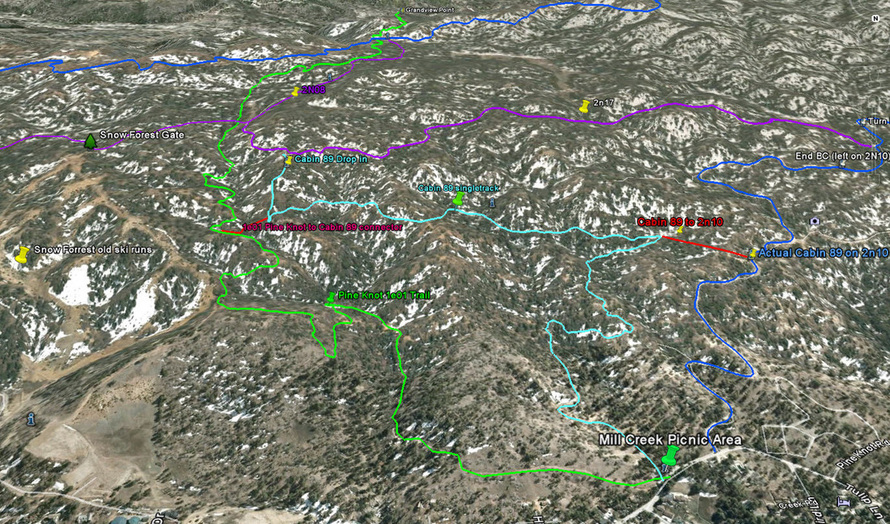
Download bigger version of this 3d image.

pineknottrailge.jpg
File Size: 387 kb
File Type: jpg
Download File

Download .KMZ file to Google Earth or your GPS device below!

1e01_-_pine_knot_trail.kmz
File Size: 8 kb
File Type: kmz
Download File

Pine Knot Trail 1e01 Video

This video starts where the green and purple tracks meet on the map above. If you start from Grandview point you will get a longer ride.
© 2001-Today, All Rights Reserved. BigBearHostel.com

Site Design by AdvertiseBigBear.com (Contact us to Advertise Here!)Join BigBear247.com for free web advertising!

WARNING:
Mountain Biking, Hiking and even watching TV on your sofa can be deadly!
Always take, food, water, warm clothes, compass, GPS, Map, Cell Phone, First Aid, doctor, friend, extra survival equipment into the National Forest or wilderness. 
This site is for informational reference purposes only. Trails may be unmarked, marked, or not even exist anymore. Use at your own risk. 


Photos used under Creative Commons from ArkansasOutside.com, Rick's Images