Big Bear Mountain Biking Trail Guide Maps GPS - Hiking Trails too!
  • Home
    • Big Bear Mountain Bike Blog
    • Big Bear Bike Forums
    • Snowshoe Club>
      • Sugarloaf Mountain
  • Mountain Bike Trails
    • 2N10 WEST TRAILS>
      • Cabin 89 Singletrack Trail>
        • Upper Cabin 89 Trail
      • Plantation Trail
      • Stonehenge Trail
      • Boulder Creek Trail
    • 2N10 EAST SNOW SUMMIT AREA>
      • Skyline Trail *NEW Singletrack for 2013*
      • Downhill Trails @ Snow Summit
      • Pine Knot Trail>
        • Pine Knot Trail -1e01
      • Towne Trail
      • Snow Forest Trail 2N08 Singletrack
      • Plumber's Trail (2012)
    • NORTH SIDE / FAWNSKIN>
      • Grout Bay - Hanna Flats Loop w/Gray's Peak Trail - Fawnskin, CA (Big Bear Lake, Ca)
      • Gray's Peak Trail - Fawnskin, CA (Big Bear Lake, Ca)
      • Butler Peak Fire Lookout Fireroad Climb (Big Bear Lake, Ca)
      • Cougar Crest to Bertha Peak Trail
      • Woodland Nature Trail
      • Don't Shoot Me Trail
    • Epic XC Rides>
      • Big Bear Epic XC Loop #1
      • Big Bear Epic XC Loop #34
      • Big Bear XC Ride #5
      • Big Bear XC Ride #9
    • NEARBY>
      • Exploration Trail
      • Santa Ana River Trail Guide>
        • SART "Segment 0" Wildhorse Trail
        • SART "Segment 1" Southfork to Angeles Oaks
        • SART "Segment 2" Angeles Oaks to Morton Peak
        • SART "Segment 3" Morton Peak Singletrack to Redlands
        • Old Highway 38 to SART Loop (Loch Leven Santa Ana River Trail)
    • Trails coming soon... >
      • Polique to Delamar Connector Singletrack
      • Fern Trail
      • Snow Summit Chairlift MTB Loops
  • Snow Summit Downhill Runs
  • Big Bear Information
    • Hiking Trails>
      • Alpine Pedal & Walking Path
      • Best Hike from Big Bear Lake Village Area
      • Castle Rock Trail (**MUST DO** Most Scenic Destination)
      • Cougar Crest Trail
      • Pine Knot Trailhead Loops
      • Woodland Nature Trail
      • Siberia Creek Trail "Gunsight"
      • Gold Mountain Short Hike (Winter)
      • The PCT - Pacific Crest Trail
    • Big Bear Bicycle MTB Shops / Rentals
    • Big Bear Weather
    • Big Bear Paddle Guide
    • Other Things To Do in Big Bear Lake
    • Big Bear Beer / Pubs / Nightlife
    • Big Bear Lodge for Groups!
    • MTB Friendly Hostel
    • Buy a Big Bear Trail Map!
    • 4x4 Roads>
      • Gold Fever Self Guided History Tour

The Ultimate Mountain Bike Guide to Santa Ana River Trail Singletrack!
Maps GPS Pictures Video
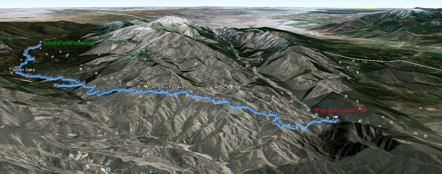
Segment 1 - Southfork to Angeles oaks

OPTIONS: 
1) Shuttle from top to bottom - Drop bikes and riders at the top. Drive 2 cars down 38 and Glass Road and Seven Oaks Road and leave 1 car at the bridge where Seven Oaks road meets Mill Creek Road(middle control). Drive back up and start riding down to your car.

2) Park at Glass Road. Ride up or down as far as you want.

3) Park at Southfork and ride down SART to Mill Creek Road, down to bridge, then all the way up the canyon roads to your car.

4) Ride down Wildhorse Trail which comes out on 38 above South Fork and make an EPIC Shuttle!

5) Start from the top of Poop Out Hill near Jenks Lake and tie in more singletrack! (details coming soon) 

6) Keep going from Southfork to Angeles Oaks down the Lower SART!


Santa Ana River Trail (ride as a loop from Angeles Oaks) 

SART from Angelus Oaks to South Fork (return)


Santa Ana River Trail 
(Southfork down past Angeles Oaks almost to Morton Peak)

Google Earth View 
Southfork to Angeles Oaks to HWY 38 near Morton Peak

Picture
© 2001-Today, All Rights Reserved. BigBearHostel.com

Site Design by AdvertiseBigBear.com (Contact us to Advertise Here!)Join BigBear247.com for free web advertising!

WARNING:
Mountain Biking, Hiking and even watching TV on your sofa can be deadly!
Always take, food, water, warm clothes, compass, GPS, Map, Cell Phone, First Aid, doctor, friend, extra survival equipment into the National Forest or wilderness. 
This site is for informational reference purposes only. Trails may be unmarked, marked, or not even exist anymore. Use at your own risk. 


Photos used under Creative Commons from ArkansasOutside.com, Rick's Images