Big Bear Mountain Biking Trail Guide Maps GPS - Hiking Trails too!
  • Home
    • Big Bear Mountain Bike Blog
    • Big Bear Bike Forums
    • Snowshoe Club>
      • Sugarloaf Mountain
  • Mountain Bike Trails
    • 2N10 WEST TRAILS>
      • Cabin 89 Singletrack Trail>
        • Upper Cabin 89 Trail
      • Plantation Trail
      • Stonehenge Trail
      • Boulder Creek Trail
    • 2N10 EAST SNOW SUMMIT AREA>
      • Skyline Trail *NEW Singletrack for 2013*
      • Downhill Trails @ Snow Summit
      • Pine Knot Trail>
        • Pine Knot Trail -1e01
      • Towne Trail
      • Snow Forest Trail 2N08 Singletrack
      • Plumber's Trail (2012)
    • NORTH SIDE / FAWNSKIN>
      • Grout Bay - Hanna Flats Loop w/Gray's Peak Trail - Fawnskin, CA (Big Bear Lake, Ca)
      • Gray's Peak Trail - Fawnskin, CA (Big Bear Lake, Ca)
      • Butler Peak Fire Lookout Fireroad Climb (Big Bear Lake, Ca)
      • Cougar Crest to Bertha Peak Trail
      • Woodland Nature Trail
      • Don't Shoot Me Trail
    • Epic XC Rides>
      • Big Bear Epic XC Loop #1
      • Big Bear Epic XC Loop #34
      • Big Bear XC Ride #5
      • Big Bear XC Ride #9
    • NEARBY>
      • Exploration Trail
      • Santa Ana River Trail Guide>
        • SART "Segment 0" Wildhorse Trail
        • SART "Segment 1" Southfork to Angeles Oaks
        • SART "Segment 2" Angeles Oaks to Morton Peak
        • SART "Segment 3" Morton Peak Singletrack to Redlands
        • Old Highway 38 to SART Loop (Loch Leven Santa Ana River Trail)
    • Trails coming soon... >
      • Polique to Delamar Connector Singletrack
      • Fern Trail
      • Snow Summit Chairlift MTB Loops
  • Snow Summit Downhill Runs
  • Big Bear Information
    • Hiking Trails>
      • Alpine Pedal & Walking Path
      • Best Hike from Big Bear Lake Village Area
      • Castle Rock Trail (**MUST DO** Most Scenic Destination)
      • Cougar Crest Trail
      • Pine Knot Trailhead Loops
      • Woodland Nature Trail
      • Siberia Creek Trail "Gunsight"
      • Gold Mountain Short Hike (Winter)
      • The PCT - Pacific Crest Trail
    • Big Bear Bicycle MTB Shops / Rentals
    • Big Bear Weather
    • Big Bear Paddle Guide
    • Other Things To Do in Big Bear Lake
    • Big Bear Beer / Pubs / Nightlife
    • Big Bear Lodge for Groups!
    • MTB Friendly Hostel
    • Buy a Big Bear Trail Map!
    • 4x4 Roads>
      • Gold Fever Self Guided History Tour

Gold Mountain Short Hike - Big Bear City, CA
Elevation: Start 6620ft - End 7200ft ~ 600ft gain
Distance: 1.5 miles each way - lasso loop

Gold Mountain is a great Big Bear hike to do in Winter. The trailhead is right next to highway 18 just 10 minutes from town. 
This trail has tons of Winter sun exposure so it melts fast. There is plenty of parking just up the dirt road off the highway. 
This is a favorite 4x4 trip for jeep clubs and dog walkers. 
Just walk up the dirt road as far as you want or until you hit snow and return. The views are fantastic. 
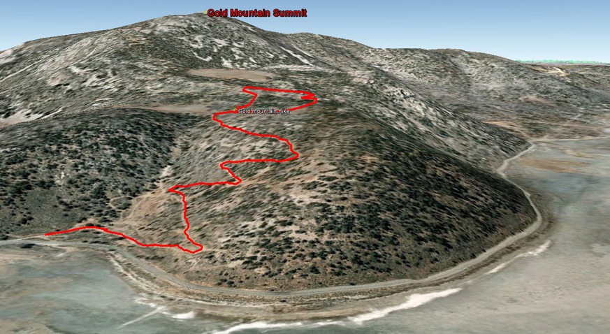
The track below shows a really fun detour / loop through a meadow to a rock outcropping with amazing desert views. If you follow the track exactly you will be making your own path but it would be hard to get lost here. Take a GPS to be sure. 
The views of Baldwin Lake and Big Bear are okay as well. :) 

Guides by Grayson - BigBearHostel.com

Gold Mountain Short Hike - 3D view in Google Earth

Picture
© 2001-Today, All Rights Reserved. BigBearHostel.com

Site Design by AdvertiseBigBear.com (Contact us to Advertise Here!)Join BigBear247.com for free web advertising!

WARNING:
Mountain Biking, Hiking and even watching TV on your sofa can be deadly!
Always take, food, water, warm clothes, compass, GPS, Map, Cell Phone, First Aid, doctor, friend, extra survival equipment into the National Forest or wilderness. 
This site is for informational reference purposes only. Trails may be unmarked, marked, or not even exist anymore. Use at your own risk. 


Photos used under Creative Commons from ArkansasOutside.com, Rick's Images